Know the exterior asset before it becomes a leak, claim, board issue, bid dispute, or capital surprise.
Drone Nation helps property managers, HOA boards, commercial owners, brokers, facilities teams, and portfolio operators turn aerial capture into a usable exterior decision file for maintenance planning, insurance documentation, reserve conversations, contractor oversight, and portfolio visibility.
We are taking decades of insurance experience — risk management, analysis, claims knowledge, and property documentation insight — and turning that into a proactive service that helps clients protect assets, improve visibility, reduce surprises, and make better decisions before issues become bigger problems.
Simple Start
Start with one property.
Keep it simple. Book a review, compare the packages, or submit one address for a recommendation.
Book 10-Minute Scope Review
Talk through the property and the right scope.
Review the packages
Compare A, B, and C before you commit.
Submit one property
Let Drone Nation recommend the best fit.
FAA Part 107 Certified
Commercial aerial operations performed by a certified remote pilot.
Enterprise Aerial Platforms
Commercial capture platforms built for property documentation, not hobbyist visuals.
Claims & Risk Analysis Mindset
Built around spotting visible conditions that can become bigger operating or claim issues later.
$2M Aviation Liability Coverage
Professional insurance structure for commercial property work.
30+ Years Insurance Risk Experience
Claims, risk management, property documentation, and insurance-industry analysis.
Thermal, Mapping & Orthomosaic Capability
Supports stronger visibility and clearer documentation where properly scoped.
Serving Fresno, Clovis, and Central Valley property teams along the Highway 99 corridor.
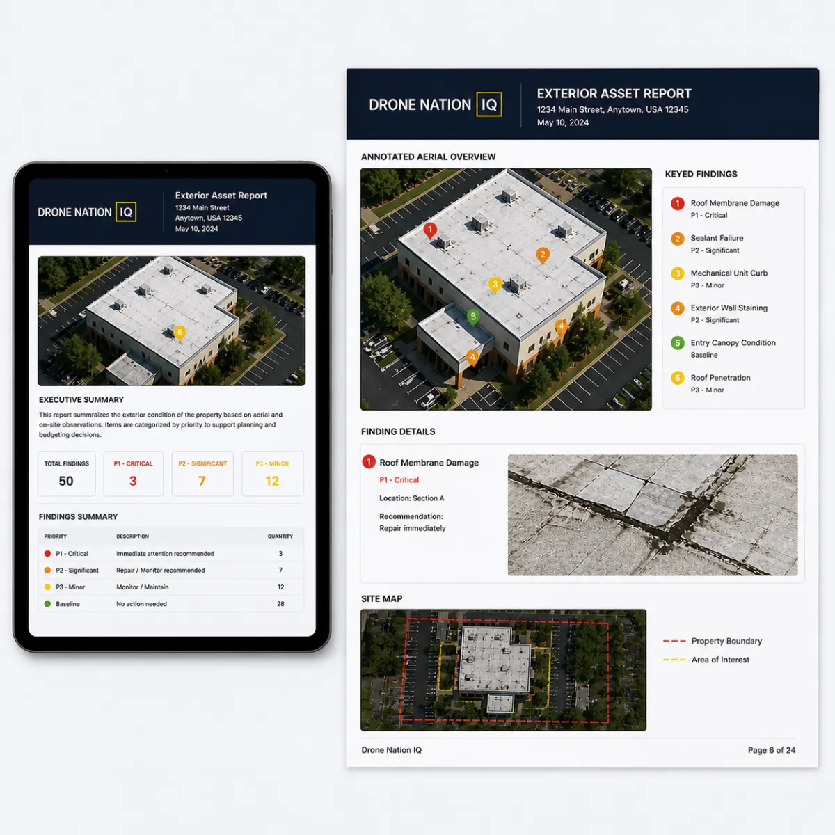
Sample Report
See what you actually receive.
This is not just imagery. It is structured exterior asset documentation built for real property decisions, not just visuals.
Executive property summary
Annotated aerial visuals
Finding matrix
P1 / P2 / P3 / Baseline priority system
Site map / orthomosaic example
Contractor reference notes
Board / owner-ready summary
Insurance / reserve planning documentation support
Drone Nation provides visual exterior documentation and decision-support reporting. We do not provide engineering opinions, roof certifications, code determinations, or contractor repair scopes. Conditions requiring technical evaluation should be reviewed by the appropriate licensed professional.
Typical Drone Vendor VS. Drone Nation
Not just drone footage. Exterior asset intelligence your team can actually use.
Drone Nation is built around clearer reporting, stronger business context, and cleaner decision support so the result works better for managers, owners, boards, brokers, and facilities teams.
Typical Drone Vendor
Often delivers attractive photo or video output with limited structure, little operational context, and no clear path for maintenance or ownership decisions.
Drone Nation
Delivers a more useful exterior property file with organized findings, action levels, visual evidence, and documentation built for real-world property decisions.
| Typical Drone Vendor Output | Drone Nation Output |
|---|---|
| Photo and video delivery | Structured exterior asset documentation |
| Limited business context | Built around maintenance, insurance, reserve, and capital decisions |
| Little or no finding structure | Organized findings with clearer sections and callouts |
| No clear priority system | Color-coded action levels that are easier to understand |
| Minimal mapping or location logic | Location-based documentation and finding references |
| No contractor-routing context | Supports trade review for roof, HVAC, paving, drainage, lighting, fencing, exterior repairs, or site issues |
| One-off visuals | Repeatable reporting for one property or a portfolio |
| Mostly media output | Decision-grade documentation for owners, boards, managers, and facilities teams |
| Limited before / after verification | Can support vendor proof, progress documentation, and condition tracking |
| Limited site-level context | Captures broader site systems, common areas, perimeter exposure, and support assets |
| No board or ownership framing | Can roll into stronger board packets, ownership updates, and formal presentation support |
| Reactive after-the-fact imagery | Proactive visibility designed to reduce surprises and support better asset decisions |
The Problem
Most exterior asset decisions are made with incomplete visibility.
Property teams are stuck comparing contractor opinions, scattered cell-phone photos, old roof notes, insurance pressure, board questions, tenant complaints, and capital requests without an organized visual intelligence layer.
Deferred maintenance hides.
Roof drainage, stains, flashing, HVAC platforms, parking surfaces, and drainage issues often go undocumented until they become expensive.
Bids are hard to compare.
Drone Nation IQ gives managers neutral documentation to support bid review and vendor accountability.
Insurance needs proof.
Exterior condition documentation helps support carrier, broker, renewal, and claim conversations.
Portfolios need ranking.
Owners need to know what to repair, monitor, budget, document, or escalate.
Who We Serve
Property types where exterior visibility creates real operating value.
Drone Nation is built for properties where roofs, drainage, parking, common areas, building envelope issues, lighting, perimeter conditions, and site assets create recurring management pressure.
Multifamily
Garden-style communities, townhome communities, and multi-building residential assets where roofs, drainage, walkways, lighting, parking, and exterior conditions create recurring management decisions.
Apartment Complexes
Apartment communities with repeated building types, shared roofing, common areas, exterior stairways, and site systems that benefit from organized visual documentation.
Retail Centers
Shopping centers, neighborhood retail, and tenant-facing properties where roof, HVAC, parking, lighting, signage, and drainage affect tenant experience and ownership decisions.
Strip Centers
Smaller retail centers and service plazas where shared parking, storefront visibility, roof condition, lighting, and common-area upkeep need consistent documentation.
Office Buildings
Professional office properties where exterior condition, roof systems, parking, access routes, and curb appeal support ownership and facilities decisions.
Medical Offices
Medical office properties where access, parking, roofing, site condition, lighting, and building-envelope visibility support patient-facing operations.
Industrial & Warehouses
Warehouse, industrial, flex, and distribution properties where large roofs, loading zones, service yards, drainage, and lighting require repeatable exterior visibility.
Mixed-Use Properties
Properties combining retail, office, residential, or common areas where multiple stakeholder groups need a more organized exterior asset file.
Schools & Churches
Campus-style properties with multiple buildings, gathering areas, walkways, roofs, parking, and site assets that benefit from clearer exterior documentation.
Self-Storage
Storage properties with drive aisles, rooflines, gates, fencing, security visibility, and drainage concerns that need organized site review.
HOA & Condo Associations
Communities with shared roofs, streets, amenities, hardscape, fencing, gates, and reserve-related exterior assets that boards need to review clearly.
Large Portfolios
Owners, managers, and asset teams who need consistent exterior documentation across multiple sites for comparison, prioritization, and planning.
Who We Don’t Serve
Who Drone Nation Is NOT For
This is not for buyers looking for cheap drone photos, real estate beauty shots, or one-off aerial media. Drone Nation is for property decision-makers who need organized exterior documentation for maintenance, insurance, reserve planning, contractor oversight, and asset decisions.
Why Use Us
Why Property Managers Use Drone Nation
Why they need us, what we do for them, and how we make their job easier.
1. WHY THEY NEED US
Incomplete Visibility – You can’t manage what you can’t see. We reveal issues that aren’t visible from the ground.
Deferred Maintenance Surprises – Small issues grow into budget-breaking problems. We help you catch them early.
Contractor Disputes – No clear documentation means he said, she said. We provide objective, time-stamped evidence.
Insurance Documentation Gaps – Carriers require proof. We deliver the photos and data you need.
Reserve Planning Guesswork – Accurate planning requires accurate data. We remove the guesswork.
Board / Owner Communication Friction – Your stakeholders want clarity and proof. We make it easy to show them.
2. WHAT WE DO
Aerial Capture – High-resolution drone imagery of roofs, building exteriors, site features, and hardscapes.
Roof & Drainage Review – Identify membrane issues, ponding water, scuppers, downspouts, and drainage paths.
Exterior Envelope Review – Evaluate walls, EIFS, stucco, sealants, windows, doors, flashings, and penetrations.
Parking & Hardscape Review – Assess pavement, striping, curbs, sidewalks, cracks, and expansion joints.
Lighting, Fencing & Gates – Review site lighting, bollards, fencing, gates, signage, and access components.
Rooftop HVAC & Mechanical – Capture units, curbs, screens, ducts, penetrations, and equipment conditions.
Common Area Visibility – Pools, clubhouses, amenities, landscaping, play areas, and site furnishings.
Recurring Monitoring – Scheduled re-inspections to track changes and measure maintenance impact.
Contractor Documentation – Pre-job documentation, scope verification, and post-completion validation.
Insurance Support – Condition documentation for renewals, claims, and loss-prevention reporting.
3. TYPICAL DELIVERABLES
Executive Summary – High-level overview of property condition, key risks, and recommended actions.
Annotated Images – Labeled photos with callouts so issues are easy to find and understand.
Finding Matrix – Organized list of observations by system and priority with location references.
Action-Level Priorities – Recommended actions with priority tiers (High / Medium / Low) and rationale.
PM Notes Section – Space for your team to add notes, assign tasks, and log updates.
Board / Owner-Ready PDF – Professional report designed for easy review and clear decision-making.
4. COMMON USE CASES
Annual Condition Baseline – Establish a current-state baseline to guide budgets and planning.
Board Packet Support – Provide clear, visual documentation for board and owner meetings.
Reserve Study Support – Deliver accurate data to support reserve studies and capital planning.
Contractor Bid Comparison – Ensure scopes are complete and bids are apples-to-apples.
Pre / Post Repair Verification – Document conditions before work begins and verify quality after completion.
Insurance Documentation – Provide the detail carriers need for renewals, claims, and loss-prevention.
Inspection Modules
What Drone Nation can document across the visible exterior.
The goal is to cover the exterior pain points that matter to property managers, HOAs, ownership groups, and commercial facilities teams — not just the roof, but the broader asset picture around it.
Roof Systems
Roof zones, membranes, shingles, flashing, penetrations, parapets, coping, visible repairs, staining, rooftop-mounted structures, chimneys, roof-mounted antennas, and ponding indicators.
Drainage
Roof drains, scuppers, box gutters, gutters, downspouts, overflow points, runoff paths, low spots, and visible drainage trouble areas from roof to grade.
HVAC & Mechanical Systems
Rooftop and ground-mounted HVAC, package units, condensers, line sets, curbs, screens, visible rust, damaged panels, access constraints, and surrounding support equipment.
Exterior Inspections & Building Envelope
Exterior walls, cladding, parapets, windows, doors, sealants, facade conditions, wall-mounted antennas, wall-mounted satellites, and water-track indicators.
Parking, Curbing & Hardscape
Parking lots, striping, curbs, sidewalks, ramps, hardscape, hard deck areas, pathways, walkways, cracking, potholes, displacement, and visible trip-risk conditions.
Lighting, Carports & Site Structures
Light poles, carports, detached covers, rooftop screens, site structures, mounted structures, and lighting visibility throughout the property.
Solar, Utilities & Site Support Assets
Solar arrays, utility zones, sprinkler visibility, fire-suppression related site features, service equipment areas, and other visible support systems.
Garbage, Fencing, Gates & Perimeter
Dumpster and garbage areas, enclosures, fencing, swinging gates, access gates, pathway gates, perimeter conditions, and exposed site-control issues.
Amenities, Pools & Common Areas
Swimming pools, clubhouses, playgrounds, courts, shared amenities, gathering areas, and exterior common-area conditions that affect residents, owners, and boards.
Patios, Pergolas, Canopies & Awnings
Patio areas, pergolas, canopies, awnings, shade structures, and other visible aesthetic or functional exterior features that influence upkeep and appearance.
Landscape, Grounds & Irrigation
Grass, planting beds, landscape zones, irrigation visibility, overspray indicators, grade concerns, and site appearance issues that affect curb appeal and maintenance planning.
Fire / Safety Visibility
Visible fire-lane markings, extinguisher cabinet areas, egress-related conditions, access routes, and site visibility concerns that may warrant closer specialist review.
Process
What Happens After You Order
A clear, step-by-step process designed to move from property input to decision-ready documentation without confusion or delay.
| Step | What Happens |
|---|---|
| 1. Submit One Property | Client enters address, property type, building count, and concern |
| 2. Scope Confirmation | Drone Nation confirms package, access, airspace, timing, and deliverables |
| 3. Field Capture | Aerial / thermal / mapping / ground documentation captured as scoped |
| 4. Drone Nation Report | Client receives organized exterior asset documentation for decisions, bids, insurance, reserves, or board review |
Packages
Choose the level of exterior intelligence that fits the property and the decision.
Each package is scoped by building and site conditions. Package B is the recommended starting point for most managed properties, while Package C is best for larger, more complex, or broader reporting needs.
Focused Exterior Scan
One issue, one building, one concern.
Per-building / defined-scope starting package.
Best for one known exterior concern, one building, or one clearly defined system.
Not intended to automatically cover an entire complex, all buildings, or every exterior component unless those buildings and components are included in the scope.
Additional buildings can be added when scoped, with same-site multi-building pricing available.
Targeted aerial capture focused on a specific issue, condition, or zone.
Useful for a roof concern, drainage problem area, exterior complaint, HVAC visibility check, parking issue, or other known need.
Executive summary with the primary findings and what was documented.
Annotated visuals and callouts tied to the main area of concern.
Good entry point for owners or managers who want to start small before expanding scope.
This is a focused starting package, not automatic whole-complex coverage unless the full complex is scoped.
Standard Exterior Intelligence
Default for most managed properties.
Recommended starting point for most managed properties.
Per-building / same-site scope that can scale to additional buildings at the same property.
Best when the client needs broader exterior visibility rather than a single-issue scan.
May include roof systems, drainage, HVAC and mechanical systems, exterior inspections and building envelope, parking, hardscape, lighting, carports, site structures, perimeter areas, and common areas.
2D orthomosaic / site map included where site, weather, and flight conditions allow.
Management-ready summary organized around visible findings and action categories.
Annotated visuals, issue callouts, and clearer documentation structure.
Color-coded action priorities: P1 Escalate, P2 Plan, P3 Monitor, and Baseline.
Useful for maintenance planning, reserve discussions, contractor scoping, ownership updates, and insurance documentation.
Multi-building same-visit scope can be structured so additional buildings are added more efficiently than separate one-off visits.
Recommended default package for most managed assets and multi-building same-site work.
Enterprise & Portfolio Intelligence
Portfolios, board packets, capital planning, and stakeholder decisions.
Everything in Package B, expanded for larger, more complex, or multi-building properties.
Best when the client needs a stronger decision file, broader site visibility, or more robust reporting for multiple stakeholders.
Per-building / same-site scope that can scale across larger communities, campuses, portfolios, and multi-building sites.
3D model / digital twin and point-cloud capable workflows where the property, scope, and capture plan support it.
Better fit for larger apartment communities, mixed-use properties, industrial sites, campuses, HOA communities, and portfolio work.
Creates a more robust visual record of site relationships, elevations, structures, access, and surrounding asset context.
Useful for ownership groups, boards, reserve planning, capital planning, due diligence, insurance documentation, and portfolio-level comparison.
Supports stronger presentation value for board packets, formal reporting, owner updates, and multi-party review.
Can be paired with Ground 360° Walkthroughs, progress visits, vendor proof visits, and formal report add-ons.
Ideal when broader documentation depth is needed now so the client has better visibility later.
Built for larger decisions, broader visibility, and stronger reporting depth.
Multi-Building Scope & Project-Based Pricing
Each project is scoped around the property, building count, site complexity, access, airspace, deliverables, and timing. Packages begin with a defined building / site scope. Additional buildings at the same property can be added to the same visit, and multi-building or portfolio work can be structured more efficiently than separate one-off projects.
Defined project scope
Each package begins with a clear building / site scope so the client knows what is included before scheduling.
Same-site building additions
Additional buildings can be added when they are part of the same visit and included in the project scope.
Project-based pricing
Final pricing is determined by building count, size, complexity, access, airspace, deliverables, and turnaround needs.
Portfolio loyalty structure
Recurring and multi-property clients may qualify for volume-based program structure when scope is established.
Add-On Services
Specialized flights, walkthroughs, or presentation add-ons that can be layered onto a package when the property needs more depth.
Thermal / Moisture Scan
Vertical Facade Inspection
Interior Scan — Common Area
Interior Scan — Unit / Suite
Same-Day Mobilization
Board Packet / Formal Report
Rapid Incident Response
CapEx / Construction Progress
Ground 360° Walkthrough — Large (11+ buildings)
Ground 360° Walkthrough — Small (1–4 buildings)
Ground 360° Walkthrough — Mid (5–10 buildings)
EEE Documentation (SB 721/326)
Vendor Proof Visit (Before / After)
Rush Delivery
Buyer Paths
Choose your role and see what matters.
Different buyers care about different outcomes. Select your role to understand what you get and how to move forward.
| Buyer | What They Care About | |
|---|---|---|
| Property Manager | Fewer surprises, vendor accountability, owner updates | Get Manager Scope |
| HOA Board / CAM | Board packets, reserve documentation, common-area visibility | Get HOA Review |
| Commercial Owner | Protect NOI, plan CapEx, document asset condition | Get Owner Review |
| Facilities Director | Maintenance visibility, access constraints, repeatable documentation | Get Facility Scope |
| Broker / Advisor | Due diligence, listing support, buyer/seller confidence | Get Asset Visibility File |
| Insurance / Risk Advisor | Exterior documentation, renewal conversations, property condition records | Get Risk Documentation Scope |
Clear Action Levels
Professional, color-coded priorities after the property is reviewed.
Each visible condition can be organized into an action lane that is easier to understand in owner updates, board packets, maintenance planning, and vendor discussions.
P1
Escalate
Visible condition may require prompt specialist review because of water intrusion, safety, access, operational, or higher-cost exposure.
P2
Plan
Condition appears to need vendor review, maintenance planning, cleaning, bid comparison, or budget attention.
P3
Monitor
Visible wear or a lower-level condition should be tracked and rechecked during the next review cycle.
INFO
Baseline
Area is documented for the property file with no immediate visible concern identified at the time of review.
Professional Capture Stack
Insurance-informed capability, turned into a proactive client service.
Drone Nation combines commercial aerial systems, thermal and mapping capability, Ground 360° walkthroughs, and insurance-informed reporting so the final deliverable is more credible and more usable. The value is not just capture — it is bringing decades of risk, claims, and analysis thinking into a proactive asset-visibility service.
FAA Part 107 Certified
Commercial aerial operations performed by a certified remote pilot.
30+ Years Insurance Risk Experience
Claims, risk management, property documentation, and insurance-industry analysis.
Enterprise Aerial Platforms
Commercial capture platforms built for property documentation, not hobbyist visuals.
Thermal, Mapping & Orthomosaic Capability
Supports stronger visibility and clearer documentation where properly scoped.
Ground 360° Walkthroughs
On-site walkaround documentation that gives clients a real-world view of the surroundings and common areas.
Decision-Grade Reporting
The deliverable is a cleaner property file designed for real property decisions.
Frequently Asked Questions
Is this a roof inspection?
No. Drone Nation provides exterior visual documentation and intelligence reporting. We are not replacing licensed roofers, engineers, architects, or code officials.
Can this support insurance conversations?
Yes. The report can help organize exterior condition documentation for brokers, carriers, renewal discussions, underwriting questions, and claim-related property records.
Can this help compare contractor bids?
Yes. Drone Nation IQ can provide neutral visual documentation so managers and owners can compare scope areas, visible conditions, before/after work, and vendor claims.
Do you inspect every building automatically?
No. Every project is scoped by building count, site size, access, airspace, timing, and deliverables.
How fast do we get the report?
Standard reports are typically delivered within 3–5 business days after field capture. Rush delivery and same-day mobilization may be available depending on scope, weather, airspace, and site complexity.
Start
Submit one property and let Drone Nation help recommend the right scope.
Start with one address. Tell us the property type, building count, your main concern, and whether you want a focused scan, a standard exterior intelligence package, or a larger portfolio-level review.
Property Review Request
Questions before you book?
Use the contact options below, or scan the QR code to visit DroneNationUSA.com.
559-517-3777
DroneNationUSA.com

FAA Certified Remote Pilot
Commercial aerial operations under FAA Part 107 standards.